Built during World War II, the Alaska Highway remains one of the most ambitious infrastructure projects ever undertaken in North America. Constructed under extreme environmental conditions and unprecedented time pressure, the highway connected the continental United States to Alaska through Canada and permanently altered transportation, defense planning, and engineering practice in cold regions.
The highway opened to civilian traffic in 1948 and immediately transformed access to Alaska, but its origins were firmly rooted in wartime urgency rather than civilian mobility. The project combined military engineering, civilian labor, and improvisation at a scale rarely seen before or since.
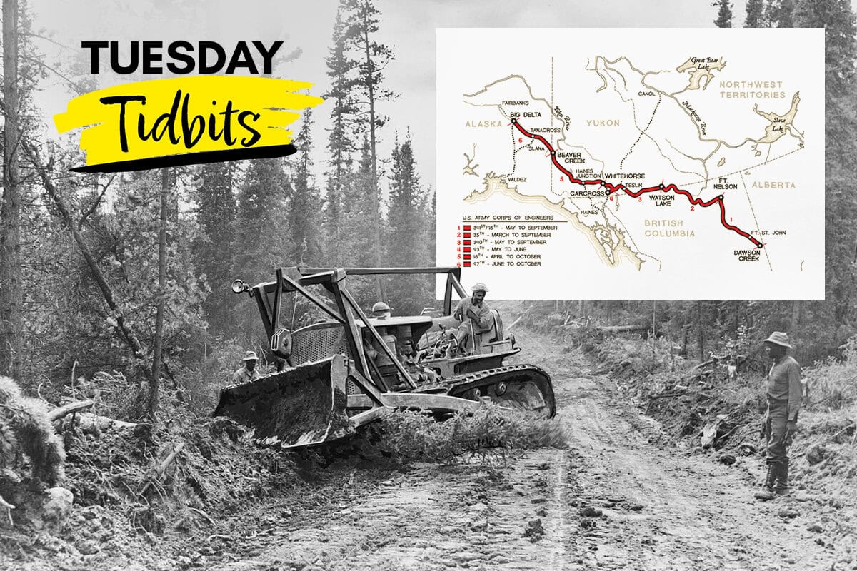
The Alaska Highway begins at Dawson Creek, British Columbia, and runs to Delta Junction, Alaska, passing through British Columbia, Yukon, and Alaska. Upon its initial completion in 1942, the route measured approximately 2,700 km (1,700 miles). Over subsequent decades, realignments and straightening reduced the length to approximately 2,232 km (1,387 miles) by 2012. Once legendary for its rough conditions, the highway is now paved along its entire length, although reconstruction and upgrades continue.
Paving the Way
Discussions about a land route connecting the continental United States to Alaska circulated in the late 1920s and early 1930s. Early proposals emphasized economic development and tourism, but because much of the route would pass through Canada, Canadian government support was essential. At the time, Canadian officials questioned the value of funding a road that would primarily serve Alaska and the sparsely populated Yukon.
In 1929, British Columbia proposed a highway to Alaska as a means of encouraging economic growth and tourism. A U.S. Canadian study process in the early 1930s reviewed proposed routes and cited economic and strategic arguments for a highway. In the mid-1930s, further discussions suggested the United States might fund the Alaska portion of the highway, with Canada responsible for the remainder. The Great Depression and continued political hesitation stalled progress.
By the mid-1930s, geopolitical conditions began to influence the conversation. During a visit to Canada in mid-1936, U.S. President Franklin D. Roosevelt emphasized the military value of a highway that could rapidly reinforce Alaska in the event of a foreign crisis. By 1938, British Columbia Premier Duff Pattullo supported a route through Prince George, and the United States explored financing options, including covering a significant portion of construction costs.
The strategic importance of Alaska increased dramatically after the Japanese attack on Pearl Harbor in December 1941. Japanese military activity in the Aleutian Islands further heightened concerns about the defense of North America’s northwest flank. Under these conditions, the highway shifted from a long-debated infrastructure concept to a military necessity.
In February 1942, U.S. and Canadian defense authorities approved moving forward, followed by formal U.S. Canada agreements in March 1942. The project received authorization from Congress and President Roosevelt, and responsibility for execution fell primarily to the U.S. Army Corps of Engineers, supported by civilian contractors.
The Construction
Construction of the Alaska Highway began in March 1942, with mobilization and start dates commonly cited between March 9 and March 11. The urgency of the project was underscored in June 1942, when Japanese forces attacked Dutch Harbor, Alaska, killing 43 American servicemen and wounding 50 others. Although the highway itself was not directly involved in combat, the attacks reinforced the strategic need for a reliable overland supply route.
Initial shipments of construction equipment arrived by ship at the port of Valdez and by air to Northwest Staging Route airfields. Equipment inventories included hundreds of graders, tractors, steam shovels, and thousands of trucks, along with bulldozers, cranes, snowplows, and generators. More than 10,000 soldiers were deployed, supported by approximately 250,000 tons of materials.
Rather than building from a single starting point, multiple engineer regiments were stationed at strategic locations along the proposed route. Construction progressed northward and southward simultaneously, with crews eventually meeting to complete the corridor. Bulldozers cleared corridors roughly 50 to 90 feet wide, followed by teams that hastily flattened road surfaces to establish a passable route.
Environmental conditions posed immediate and severe challenges. Crews encountered muskeg, a swampy layer of decaying vegetation, along with permafrost, dense forests, and heavy spring rains. In many areas, conventional construction methods failed. When attempts to bypass muskeg proved ineffective, crews resorted to corduroy construction, cutting trees by hand, laying logs across unstable ground, and covering them with fill. These methods were labor intensive and slowed progress significantly.
By early summer 1942, the combined effects of terrain, weather, and logistical constraints had taken their toll. Despite these setbacks, construction accelerated as military pressure increased following Japanese operations in the Aleutian Islands.
In late September 1942, construction crews working from opposite directions met near the British Columbia Yukon border, marking a major linkup milestone. The final northern linkup occurred in late October 1942, completing the pioneer road. The highway was officially dedicated on November 20, 1942 at Soldier’s Summit, although it remained unsuitable for general civilian traffic until additional improvements were made in 1943.
Post-Construction Challenges and Improvements
Following its initial completion, the Alaska Highway required continuous modification. In 1943, sections of the route between Burwash Landing and Koidern, Yukon, became nearly impassable as permafrost thawed after vegetation removal. Corduroy roads were constructed to restore access, and remnants of these early solutions remain beneath some sections of the highway today.
Modern cold-region construction methods seek to preserve permafrost stability by insulating the ground or replacing native soils with gravel. Despite these advances, permafrost remains an ongoing challenge. Sections rebuilt in the late twentieth century continue to experience frost heave and settlement.
Paving of the Alaska portion of the highway was completed in the 1960s. Since then, realignment of dangerous curves, widening for modern traffic, and replacement of original steel bridges have continued. These improvements remain necessary to bring the highway in line with contemporary safety and performance standards.
Engineering Significance
The Alaska Highway illustrates the tradeoffs inherent in emergency infrastructure construction. Speed and strategic necessity dictated many early decisions, often at the expense of long-term durability. Limited understanding of cold-region soils, combined with extreme time constraints, resulted in infrastructure that required decades of refinement.
The project also demonstrates the importance of adaptability in engineering practice. Faced with incomplete data and unpredictable conditions, engineers relied heavily on judgment, improvisation, and field experience. Many techniques used during construction influenced later developments in cold-region and geotechnical engineering.
Conclusion
The Alaska Highway was not a failure, nor was it a disaster. It was an extraordinary engineering response to extraordinary circumstances. Built rapidly under wartime pressure, it achieved its strategic objective while revealing the limits of contemporary construction knowledge.
For modern engineers, the highway serves as a lasting case study in emergency project delivery, environmental constraint management, and infrastructure evolution. Its continued modification underscores an enduring lesson of engineering practice, that infrastructure is not static, but a system that must adapt as understanding, technology, and expectations change.


Leave A Comment